Fitzroy Island
last visited July 2016

I've stayed 3 times at Fitzroy - first in the early 90s (camping), next late 90s (in the old resort's backpacking section) and lately in July 2016 (camping again). It's an island well worth repeat visits.
 Fitzroy is about 30 km east of Cairns - the closest island to that city for day-trippers
 It is a continental island (a former mainland mountain isolated when sea level rose after the last ice age), not a coral cay like other touristy island destinations out of Cairns. Much is covered with rainforest thru which you can trek on good tracks. A fringing reef surrounds most of the island offering some good snorkeling and diving, although coral quality has suffered because of bleaching since my earlier visits. There are a couple on nice beaches, some good viewpoints and apart from GREEN ISLAND'S very flash place it is the only island out of Cairns with a resort. I don't know any others you can camp on either.
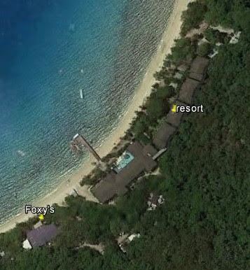
 Size is abt 3km x 1.5km. The highest point (the SUMMIT) is 375m and has a good viewpoint. The trek up there is a good work-out too. FOXY'S is a pretty nice bar/bistro with a great outlook over MAIN/RESORT BAY
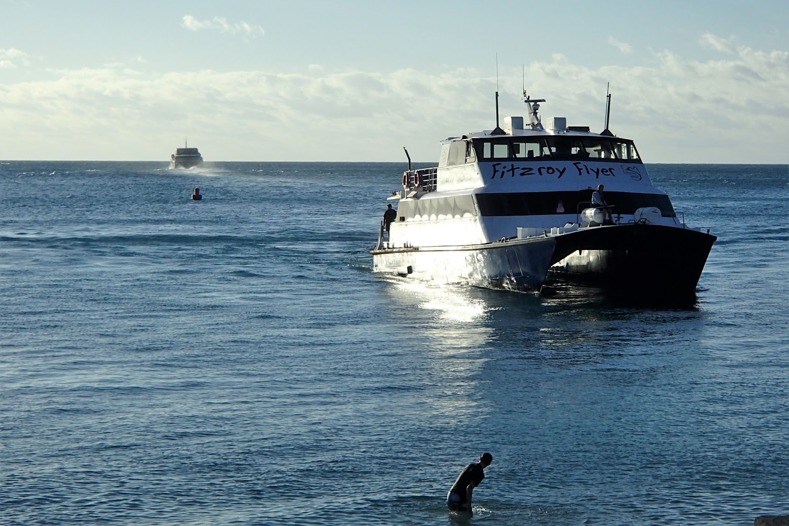
GETTING THERE - I used the resort's fast catamaran but there are several other operators who run out there although for some this is just part of a multi-destination day trip.
 Resort cat approaches pier as another operator heads back to Carins. The resort boat cost $78 return and runs out and back 3 times daily leaving Cairns at 0800, 1100 and 1330 - returning 0930, 1215 and 1700. One way takes 45 minutes.
This is not a bad trip - my main criticism is there is no courtesy shuttle transfer from Cairns accommodation to the Reef Marina departure point.
 TIP - on fine weekends make sure you get on early - Fitzroy is very popular with local day-trippers and seating can be a premium. There must have been a least 5 young couples with baby strollers on my outward trip - I think South Cairns pre-school was having a day out. What with daytrippers, resort guests, a few campers like me and some resort staff it got a bit squeezy. Not dissimilar in the sheltered seating areas top and lower decks too.
 On arrival, resort guests and campers head straight off the pier into reception (the resort administers the camp ground for Cairns council). A sign directs daytrippers towards the FOXY'S area and the WATERSPORTS shed which is beachside closer the pier than FOXY'S. However this area has all pay stuff - Cairns based daytrippers knew where the free gas barbeques and sheltered picnic tables were - in the camping area which....
 ....is to the other side of the pier. Less than 300m from reception and 100m from the last resort building.
The cleared tent area in image is about 65mx45m - had about a dozen tents my visit without feeling crowded - room for double that without getting too crammed. Camp area extends to beachfront - some enterprising tenters set themselves up under the beach-side trees. The sheltered picnic tables are here too - dominated by day trippers weekend lunches. No problems when they went home. New amenities block is not in this fairly recent Google Earth image.
Track near beach leaving top of image continues about 1500m to LIGHTHOUSE. The SUMMIT track leaves bottom part of the camp clearing - hidden by tree crowns.

 Chez tezza at Fitzroy. Note newish amenities block in background. This is a definite plus over the tiny old concrete thing my first visit. Was so disgusting I took myself off to the dive shop's shower/toilet area when needed. However this was not available 2016.
Not all is great with the new place however - there are no hot water showers and the place was pretty dirty despite a resort cleaner giving it a good workout daily. The joint was overwhelmed by day-trippers and passers-by on their way to the lighthouse, the turtle rehabilitation area or the rather nice eastern end of MAIN BEACH. It actually needs 2 cleanings a day - at least on weekends, school holidays etc.
 After day-trippers left, the campers took over. These overnighters were from the local area (Cairns Hospital Emergency Response nurses - what a job!) and were celebrating nearest Bec's 30th.
There is SOME hot water - the lit outside of the amenities block behind furthest ladies had washing up facilities for BBQers - one of the free BBQs is under the light towards left top of image.
HOWEVER THERE WAS NO CAMP KITCHEN! At $33 a night I expect this. Dudes like me who bus/fly into North Queeensland can't carry pots and pans let alone a proper cooler to preserve BBQ supplies/milk etc a number of days.
NOR were there any clothes washing/drying facilities (and a council directive banning improvised clotheslines). I moaned to the resort which directed me to their guest laundry - the washer and drier were less expensive than many backpackers' I used this tour and the place seemed underused - looks like the valet clothes cleaning service is popular with the guests.
SUM UP OF CAMPGROUND - a real nice area but overpriced, under maintained, under supervised and lacking in facilities.
 The new resort looked pretty nice to me - way above my pension grade - but maybe when I knock over that bank........
These rooms have tree-filtered beach-bay views - rooms in back look out at rainforested hillside which is maybe not that special for the price.
 Pool and reception area presented very well. Staff were helpful and pleasant in my limited dealings with them. Give a useful island info sheet/map on book in.
Refer to user review sites to see if you think place is worth the ask.
These shots click-expand nicely. At least on PCs - not sure abt yu phone dudes.
Dunno what their cut of my $33 a night is to administer/clean/supervise the camping area - but I reckon they could work a bit harder on the last 2 points.
 New accommodation going in about 300m east of camp-ground. Appearance and location suggests a less expensive resort option.
 This is the old resort's backpacker section I stayed in late 90s - now used for staff accommodation. Is immediately east of new resort's operating buildings.
 WATERSPORTS base between pier and FOXY'S very popular. These people embarking on around island glass bottom boat early in the day.
Inflatable pontoon mid-left had a tramboline center - immensely popular with kids. And not quite kids - this 70 yo geezer had to swim out and give it a go. OK - I'm 70 with the emotional age of 11.
WATERSPORTS has kayaks, stand up paddle boards, snorkel sets etc to burn.
 FOXY'S bar/bistro in a great location behind the western end of MAIN/RESORT BEACH. Plenty of open-air and undercover seating. This cheapskate thought prices reasonable - very similar to the same level (except location) Cairns' joints.
Very popular with daytrippers above - and when I came back in the evening, resort guests. The resort also has a dining room, but looked like the guests approved of FOXY'S value.
 I liked getting down here abt 1600, grabbing a beer (left of center) and checking the scene out on the bay. Sweet. Anice shot to click-expand.
THE STORE
Okay, I haven't a pic. It's immediately resort-side of FOXY'S. Has a limited selection of hot/fresh/prepared eats, ditto canned/packaged food, a good selection of the stuff people forget to pack on trips like this (including basic medications) and the usual touristy trinkets/t-shirts etc. Prices made this cheapskate blanch, but you gotta remember I'm a seriously low-budget traveler.
 The TURTLE REHABILITATION CENTER - sponsored by the resort. About 200m east of the camp ground on the LIGHTHOUSE TRACK
 Has a tank where various turtles are recovering plus an informative wall display of maps, photos etc each side of the camera - inner area open to the public at defined times. I have seen many similar places so didn't bother. But you might find it the duck's guts.
THE BEACHES.
Fitzroy has two main beaches, NUDEY and MAIN/RESORT. There are smaller patches of sand around the island but these need a kayak or some serious rock-hopping to access. I'm not into those these days.
NUDEY
Probably my best pic of this beach is the opening one at top of page.

 Nudey is at the western most tip of Fitzroy. It is split into 2 parts - not too many visitors venture to the far (lower in image) section: push past the rocks and trees at the far end of the first section.
You hit the beach near top of image - look for stacked shells/stones to denote exit; can be a bit confusing otherwise.
The far ends of both sections can get some wind when the prevailing south-easterlies which blow 80% of the time get a bit brisk. Push back to the top/middle end of the first beach for best shelter.
I found snorkeling a bit ordinary off the beach itself, but okay along those rocks at the top end.
 Far end of first section. This beach has been built from coral reef erosion. A lot is small bits of coral which are a bit tough underfoot. However finer sand can be found both ends and at back of beach.
 Second section not as attractive but more private. Cops the wind more.
Nudey is not supposed to be nude these days but naturists will find some sheltered spots and next to no visitors after the day-trippers go home.
MAIN/RESORT BEACH
 This 800m long beach is more sheltered from the south-easterlies. Note that the water gets very shallow between the pier (just above Fozy's in image) to the north end in the bottom quarter of the tide. The resort urges visitors not to enter the water around lowest tide to prevent coral damage. I found water off the rocks northern end plenty deep at such times.
 The full beach from the northern end which I thought the nicest area. Sand conditions very similar to Nudey.
 The best snorkeling I found was off those northern rocks. As said earlier, the coral has suffered a bit from bleaching. Plenty of nice fish. I saw one turtle (several on previous visits).
 The mid-section of the beach had these sandbags to protect the area in front of the resort from wave erosion. May have been caused by a big storm last wet season and I know for a fact that a nasty cyclone (aka hurricane/typhoon) moved through north Qld a few years back. Nudey also showed signs of erosion - the whole area bottom-left of the the opening image (top of page) was part of the beach on my earlier visits.
TREKS
Nice trekking can be done on the island. Some tracks have good viewpoints, others nice rainforest.

THE SUMMIT TRACK
In yellow above, this leads to the island's highest point and best viewpoint. You can then push on, dropping down to join the lighthouse track abt 10 mins short of that feature.
Starting point for most is at the southern end of the camp clearing (the branch leading fron the resort is closed to outsiders) - from there it is about 1km to the Summit. Slopes are a pretty equal measure of gentle,moderate and steep. At no time did I enter what I class as VERY steep, let alone HEARTBREAKER and DON'T SEND FLOWERS. It took me abt 40 mins - I climb slowly but don't stop - I'm a seriously old geezer but very fit.
I reckon people of average fitness will need a rest or two, unfit people more.
 There is a heap of step-ups along the way (I thought spacing was too wide to call any stairways) but the surface is pretty good with few haphazardly strewn rocks and tree roots. Several spots give a good outlook of the resort bay - some much better than above....
 ....like this one. The resort bay is hidden from the top viewpoint.
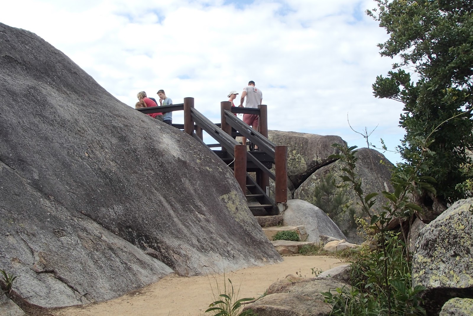
 This viewing platform at the very top is new since my previous visit. Tracks were also in much better condition and nicely signposted. I reckon the new resort has been doing some good work - although it may have been Qld National Parks (who were not noted for making a big effort in the past).
 The top view covers 270 degrees (the 90 degrees centered on norh-east is hidden) - this is the mainland coast to the south and south-west...
 ....and to the north. CAIRNS is hidden behind that high section at left.
 South is mainly ocean - you can pick out some sandy caves and parts of the outer reef on clear days. Note LIGHTHOUSE at center of image - it's a fair drop as you can see.
THE CONTINUATION OF THE SUMMIT TRACK downhill to meet the lighthouse track took me about 20 minutes. Slopes are similar to the first section but conditions underfoot are the poorest on the island - more roots and haphazard stones. However at no time did I think it was a nasty track (that's where I start slipping and go base over apex like on CAPE TRIBULATION'S MOUNT SORROW TRACK a week earlier).
THE LIGHTHOUSE TRACK is shown in white on the Google Earth image up page. Leaving fron the north end of the camping area, this one is about 1400m - doesn't go as high - took me 45mins. Slopes are equally shared between gentle, moderate and steep. There are also flat and even downhill sections - and about 200m which went into my VERY STEEP category.
 Because it is along a service vehicle track, the surface is very good. Like the SUMMIT track, there is some okay rainforest in the lower sections.
 About 10 minutes short of the lighthouse is this intersection where you can climb up to the SUMMIT in about 20 minutes. This 20 mina ia probably the roughest section of track on the island. As outlined up page his track continues downhill past the SUMMIT to the campground/resort.
The viewing platform at the above intersection has the best outlook at GREEN ISLAND. This can't be seen from the SUMMIT or LIGHTHOUSE.
 GREEN ISLAND (near far horizon - not the cloud shadow!) is part of the inner barrier reef and is the most visited island out of Cairns. It is a proper coral cay - a former atoll which has been eroded by wave attack - the debris filling the lagoon and shaped by sea and wind to form a low mounded island. GREEN ISLAND is old enough to have a fair amount of vegetation - but not the developed rainforest of Fitzroy.
By their very nature most atolls have nice fringing beaches and reefs with good snorkeling - GREEN ISLAND doesn't disappoint. Some day tour operators combine GREEN and FITZROY islands.
 Doesn't look too shabby to me (image http://www.greatadventures.com.au/)
 A little later you reach the lighthouse.
 The outlook is disappointing - about 150degrees, mainly of sea to the east and south. This is the best view of the mainland coast you get. The SUMMIT is so much better.
NUDEY AND SECRET GARDEN TRACKS

NUDEY TRACK - the white route above starts just west of FOXY'S and moves through some nice rainforest just above the oceanside rocks. Took me about 20 mins each way.
 It is not flat, but any steep sections are very short. The surface underfoot is not difficult although most is not sealed as is section in pic.
SECRET GARDEN - this (the yellow route above) is a short (maybe 20 mins return) up and back walk to a viewing platform in the middle of the island. Gradients are only moderate and the surface is fine underfoot.
 The track entry is signposted at the back of FOXY'S beer garden (background above).
 The "GARDEN" is a particularly nice section of rainforest at the platform. Pretty nice the full length of the track actually.
TRACK SUM UP
BEST VIEWS - the Summit track from the resort/camp ground.
BEST WORKOUT - up the Lighthouse track to as far as the Summit turn-off - on to the SUMMIT and then down to the resort/camp ground.
BEST RAINFOREST - the Secret Garden track.
SUNSETS
Regular users of this sit know I'm a sucker for sunsets. Like there's not too much better than sitting on a beach with a bottle of Cap'n Morgan's vibe-enhancer as that big golden orb sinks below the western horizon.
But FITZROY ISLAND has a plus - not too often do I have the chance to witness the sun sinking below the Aussie mainland from an offshore island.
 Going...
 ...going...
 ...gone!
But this one I particularly liked...

EXIT
 This board adjacent the pier shows what you missed. Gotta admit I missed that pathway immediately right of the resort heading up into mid island - looks to a waterfall or similar. The resort info sheet does not mention this. Maybe next trip. My 5th visit? Yeah, Fitzroy is that good.


I've stayed 3 times at Fitzroy - first in the early 90s (camping), next late 90s (in the old resort's backpacking section) and lately in July 2016 (camping again). It's an island well worth repeat visits.


GETTING THERE - I used the resort's fast catamaran but there are several other operators who run out there although for some this is just part of a multi-destination day trip.
This is not a bad trip - my main criticism is there is no courtesy shuttle transfer from Cairns accommodation to the Reef Marina departure point.


The cleared tent area in image is about 65mx45m - had about a dozen tents my visit without feeling crowded - room for double that without getting too crammed. Camp area extends to beachfront - some enterprising tenters set themselves up under the beach-side trees. The sheltered picnic tables are here too - dominated by day trippers weekend lunches. No problems when they went home. New amenities block is not in this fairly recent Google Earth image.
Track near beach leaving top of image continues about 1500m to LIGHTHOUSE. The SUMMIT track leaves bottom part of the camp clearing - hidden by tree crowns.


Not all is great with the new place however - there are no hot water showers and the place was pretty dirty despite a resort cleaner giving it a good workout daily. The joint was overwhelmed by day-trippers and passers-by on their way to the lighthouse, the turtle rehabilitation area or the rather nice eastern end of MAIN BEACH. It actually needs 2 cleanings a day - at least on weekends, school holidays etc.

There is SOME hot water - the lit outside of the amenities block behind furthest ladies had washing up facilities for BBQers - one of the free BBQs is under the light towards left top of image.
HOWEVER THERE WAS NO CAMP KITCHEN! At $33 a night I expect this. Dudes like me who bus/fly into North Queeensland can't carry pots and pans let alone a proper cooler to preserve BBQ supplies/milk etc a number of days.
NOR were there any clothes washing/drying facilities (and a council directive banning improvised clotheslines). I moaned to the resort which directed me to their guest laundry - the washer and drier were less expensive than many backpackers' I used this tour and the place seemed underused - looks like the valet clothes cleaning service is popular with the guests.
SUM UP OF CAMPGROUND - a real nice area but overpriced, under maintained, under supervised and lacking in facilities.

These rooms have tree-filtered beach-bay views - rooms in back look out at rainforested hillside which is maybe not that special for the price.

Refer to user review sites to see if you think place is worth the ask.
These shots click-expand nicely. At least on PCs - not sure abt yu phone dudes.
Dunno what their cut of my $33 a night is to administer/clean/supervise the camping area - but I reckon they could work a bit harder on the last 2 points.


Inflatable pontoon mid-left had a tramboline center - immensely popular with kids. And not quite kids - this 70 yo geezer had to swim out and give it a go. OK - I'm 70 with the emotional age of 11.
WATERSPORTS has kayaks, stand up paddle boards, snorkel sets etc to burn.

Very popular with daytrippers above - and when I came back in the evening, resort guests. The resort also has a dining room, but looked like the guests approved of FOXY'S value.

THE STORE
Okay, I haven't a pic. It's immediately resort-side of FOXY'S. Has a limited selection of hot/fresh/prepared eats, ditto canned/packaged food, a good selection of the stuff people forget to pack on trips like this (including basic medications) and the usual touristy trinkets/t-shirts etc. Prices made this cheapskate blanch, but you gotta remember I'm a seriously low-budget traveler.


THE BEACHES.
Fitzroy has two main beaches, NUDEY and MAIN/RESORT. There are smaller patches of sand around the island but these need a kayak or some serious rock-hopping to access. I'm not into those these days.
NUDEY
Probably my best pic of this beach is the opening one at top of page.


You hit the beach near top of image - look for stacked shells/stones to denote exit; can be a bit confusing otherwise.
The far ends of both sections can get some wind when the prevailing south-easterlies which blow 80% of the time get a bit brisk. Push back to the top/middle end of the first beach for best shelter.
I found snorkeling a bit ordinary off the beach itself, but okay along those rocks at the top end.


Nudey is not supposed to be nude these days but naturists will find some sheltered spots and next to no visitors after the day-trippers go home.
MAIN/RESORT BEACH


TREKS
Nice trekking can be done on the island. Some tracks have good viewpoints, others nice rainforest.

THE SUMMIT TRACK
In yellow above, this leads to the island's highest point and best viewpoint. You can then push on, dropping down to join the lighthouse track abt 10 mins short of that feature.
Starting point for most is at the southern end of the camp clearing (the branch leading fron the resort is closed to outsiders) - from there it is about 1km to the Summit. Slopes are a pretty equal measure of gentle,moderate and steep. At no time did I enter what I class as VERY steep, let alone HEARTBREAKER and DON'T SEND FLOWERS. It took me abt 40 mins - I climb slowly but don't stop - I'm a seriously old geezer but very fit.
I reckon people of average fitness will need a rest or two, unfit people more.


THE CONTINUATION OF THE SUMMIT TRACK downhill to meet the lighthouse track took me about 20 minutes. Slopes are similar to the first section but conditions underfoot are the poorest on the island - more roots and haphazard stones. However at no time did I think it was a nasty track (that's where I start slipping and go base over apex like on CAPE TRIBULATION'S MOUNT SORROW TRACK a week earlier).
THE LIGHTHOUSE TRACK is shown in white on the Google Earth image up page. Leaving fron the north end of the camping area, this one is about 1400m - doesn't go as high - took me 45mins. Slopes are equally shared between gentle, moderate and steep. There are also flat and even downhill sections - and about 200m which went into my VERY STEEP category.


The viewing platform at the above intersection has the best outlook at GREEN ISLAND. This can't be seen from the SUMMIT or LIGHTHOUSE.

By their very nature most atolls have nice fringing beaches and reefs with good snorkeling - GREEN ISLAND doesn't disappoint. Some day tour operators combine GREEN and FITZROY islands.


NUDEY AND SECRET GARDEN TRACKS

NUDEY TRACK - the white route above starts just west of FOXY'S and moves through some nice rainforest just above the oceanside rocks. Took me about 20 mins each way.

SECRET GARDEN - this (the yellow route above) is a short (maybe 20 mins return) up and back walk to a viewing platform in the middle of the island. Gradients are only moderate and the surface is fine underfoot.


TRACK SUM UP
BEST VIEWS - the Summit track from the resort/camp ground.
BEST WORKOUT - up the Lighthouse track to as far as the Summit turn-off - on to the SUMMIT and then down to the resort/camp ground.
BEST RAINFOREST - the Secret Garden track.
SUNSETS
Regular users of this sit know I'm a sucker for sunsets. Like there's not too much better than sitting on a beach with a bottle of Cap'n Morgan's vibe-enhancer as that big golden orb sinks below the western horizon.
But FITZROY ISLAND has a plus - not too often do I have the chance to witness the sun sinking below the Aussie mainland from an offshore island.


But this one I particularly liked...

EXIT


Komentar
Posting Komentar